Rabu, 08 Agustus 2007
Season
Season
| Part of the Nature series on Weather |
| Seasons |
|---|
| Temperate |
| Tropical |
| • Dry season • |
| Storms |
| • Thunderstorm • Tornado • |
| Precipitation |
| • Fog • Drizzle • Rain • |
| Topics |
| • Meteorology • |
| Portal · Project |
|
| ||||||||||||
A season is one of the major divisions of the year, generally based on yearly periodic changes in weather.
In temperate and polar regions generally four seasons are recognized: spring, summer, autumn (fall), and winter.
In some tropical and subtropical regions it is more common to speak of the rainy (or wet, or monsoon) season versus the dry season, as the amount of precipitation may vary more dramatically than the average temperature.
In other tropical areas a three-way division into hot, rainy and cool season is used. In some parts of the world, special "seasons" are loosely defined based upon important events such as a hurricane season, tornado season or a wildfire season.


Contents[hide] |
Causes and effects

This is a diagram of the seasons. Note that, regardless of the time of day (i.e. the Earth's rotation on its axis), the North Pole will be dark, and the South Pole will be illuminated; see also arctic winter. In addition to the density of incident light, the dissipation of light in the atmosphere is greater when it falls at a shallow angle.
The seasons result from the Earth's axis being tilted to its orbital plane; it deviates by an angle of approximately 23.44 degrees. Thus, at any given time during summer or winter, one part of the planet is more directly exposed to the rays of the Sun (see Fig. 1). This exposure alternates as the Earth revolves in its orbit. At any given time, regardless of season, the northern and southern hemispheres experience opposite seasons (see Fig. 2 and Month ranges of seasons (below) and Effect of sun angle on climate).
Seasonal weather fluctuations also depend on factors such as proximity to oceans or other large bodies of water, currents in those oceans, El Niño/ENSO and other oceanic cycles, and prevailing winds.
In the temperate and polar regions, seasons are marked by changes in the amount of sunlight, which in turn often causes cycles of dormancy in plants and hibernation in animals. These effects vary with latitude, and with proximity to bodies of water. For example, the South Pole is in the middle of the continent of Antarctica, and therefore a considerable distance from the moderating influence of the southern oceans. The North Pole is in the Arctic Ocean, and thus its temperature extremes are buffered by the presence of all that water. The result is that the South Pole is consistently colder during the southern winter than the North Pole during the northern winter.

As the Earth revolves around the Sun, the seasons in the northern and southern hemispheres are opposite.
The cycle of seasons in the polar and temperate zones of one hemisphere is opposite to that in the other. When it is summer in the Northern hemisphere, it is winter in the Southern hemisphere, and vice versa, and when it is spring in the Northern hemisphere it is autumn in the Southern hemisphere, and vice versa.
In the tropics, there is no noticeable change in the amount of sunlight. However, many regions (famously the northern Indian Ocean) are subject to monsoon rain and wind cycles. Curiously, a study of temperature records over the past 300 years (David Thompson, Science, April 1995) shows that the climatic seasons, and thus the seasonal year, are governed by the anomalistic year rather than the tropical year.
In meteorological terms, the winter solstice and summer solstice (or the date maximum/minimum insolation) do not fall in the middle of winter and summer respectively. The heights of these seasons occur up to a month later due to seasonal lag. Seasons though, are not always defined in meteorological terms; see reckoning
Compared to axial tilt, other factors contribute little to seasonal temperature changes. It's a common misconception that the seasons are the result of the variation in Earth’s distance to the sun due to its elliptical orbit.[1] Orbital eccentricity can influence temperatures, but on Earth, this effect is small and is more than counteracted by other factors; research shows that the Earth as a whole is actually a few degrees warmer when farther from the sun.[2] Mars however experiences wide temperature variations and violent dust storms every year at perihelion.[3] The sun,in its seasonal movement through the sky,passes directly over the equator each year on march and September...
Polar day and night

A common misconception is that, within the Arctic and Antarctic Circles, the sun rises once in the spring and sets once in the fall; thus, the day and night are erroneously thought to last uninterrupted for 183 calendar days each. This is true only in the immediate region of the poles themselves.
What does happen is that any point north of the Arctic Circle or south of the Antarctic Circle will have one period in the summer when the sun does not set, and one period in the winter when the sun does not rise. At progressively higher latitudes, the periods of "midnight sun" (or "midday dark" for the other side of the globe) are progressively longer. For example, at the military and weather station called Alert on the northern tip of Ellesmere Island, Canada (about 450 nautical miles or 830 km from the North Pole), the sun begins to peek above the horizon in mid-February and each day it climbs a bit higher, and stays up a bit longer; by 21 March, the sun is up for 12 hours. However, mid-February is not first light. The sky (as seen from Alert) has been showing twilight, or at least a pre-dawn glow on the horizon, for increasing hours each day, for more than a month before that first sliver of sun appears.
In the weeks surrounding 21 June, the sun is at its highest, and it appears to circle the sky without ever going below the horizon. Eventually, it does go below the horizon, for progressively longer and longer periods each day until, around the middle of October, it disappears for the last time. For a few more weeks, "day" is marked by decreasing periods of twilight. Eventually, for the weeks surrounding 21 December, nothing breaks the darkness. In later winter, the first faint wash of light briefly touches the horizon (for just minutes per day), and then increases in duration and pre-dawn brightness each day until sunrise in February.
Reckoning
Four Seasons
| Tradition | Meteorology | Astronomy | Months (North/South) |
|---|---|---|---|
| Winter | Winter | Winter | Jan/Jul |
| Spring | Feb/Aug | ||
| Spring | Mar/Sep | ||
| Spring | Apr/Oct | ||
| Summer | May/Nov | ||
| Summer | Jun/Dec | ||
| Summer | Jul/Jan | ||
| Autumn | Aug/Feb | ||
| Autumn | Sep/Mar | ||
| Autumn | Oct/Apr | ||
| Winter | Nov/May | ||
| Winter | Dec/Jun |
The date at which each of the four temperate season begins varies from culture to culture. In general there are three reckonings, "Astronomical", "Meteorological", and "Traditional".[4]
Astronomical
In astronomical reckoning, the seasons begin at the solstices and equinoxes. The cross-quarter days are the midpoints of the Astronomical seasons. The length of these seasons is not uniform because of the elliptical orbit of the earth and its different speeds along that orbit (see Kepler's laws of planetary motion).
In the conventional US calendar:
- Winter (89 days) begins on 21-22 Dec, the winter solstice
- Spring (92 days) on 20-21 Mar, the spring equinox
- Summer (93 days) on 20-21 June, the summer solstice
- Autumn (90 days) on 21-22 Sept, the autumn equinox
The cross-quarter days are considered seasonal midpoints:
- Winter: 5-10 Nov (Samhain, 立冬)
- Spring: 2-7 Feb (Imbolc, 立春)
- Summer: 4-10 May (Beltane, 立夏)
- Autumn: 3-10 Aug (Lughnasadh, 立秋)
Meteorological
| year | Equinox Mar | Solstice June | Equinox Sept | Solstice Dec | ||||
|---|---|---|---|---|---|---|---|---|
| day | time | day | time | day | time | day | time | |
| 2002 | 20 | 19:16 | 21 | 13:24 | 23 | 04:55 | 22 | 01:14 |
| 2003 | 21 | 01:00 | 21 | 19:10 | 23 | 10:47 | 22 | 07:04 |
| 2004 | 20 | 06:49 | 21 | 00:57 | 22 | 16:30 | 21 | 12:42 |
| 2005 | 20 | 12:33 | 21 | 06:46 | 22 | 22:23 | 21 | 18:35 |
| 2006 | 20 | 18:26 | 21 | 12:26 | 23 | 04:03 | 22 | 00:22 |
| 2007 | 21 | 00:07 | 21 | 18:06 | 23 | 09:51 | 22 | 06:08 |
| 2008 | 20 | 05:48 | 20 | 23:59 | 22 | 15:44 | 21 | 12:04 |
| 2009 | 20 | 11:44 | 21 | 05:45 | 22 | 21:18 | 21 | 17:47 |
| 2010 | 20 | 17:32 | 21 | 11:28 | 23 | 03:09 | 21 | 23:38 |
| 2011 | 20 | 23:21 | 21 | 17:16 | 23 | 09:04 | 22 | 05:30 |
| 2012 | 20 | 05:14 | 20 | 23:09 | 22 | 14:49 | 21 | 11:11 |
| 2013 | 20 | 11:02 | 21 | 05:04 | 22 | 20:44 | 21 | 17:11 |
| 2014 | 20 | 16:57 | 21 | 10:51 | 23 | 02:29 | 21 | 23:03 |
Meteorological seasons are reckoned by temperature, with summer being the hottest quarter of the year, and winter the coldest quarter of the year.
Using this reckoning, the Ancient Roman calendar began the year and the spring season on the first of March, with each season occupying three months. This reckoning is also used in Denmark, the former USSR, and Australia. In modern United Kingdom and Ireland there are no hard and fast rules about seasons, and informally many people use this reckoning.
So, in meteorology for the Northern hemisphere:
- spring begins on March 1,
- summer on June 1,
- autumn on September 1, and
- winter on December 1.
Conversely, for the Southern hemisphere:
- summer begins on December 1,
- autumn on March 1,
- winter on June 1, and
- spring on September 1.
Traditional

Traditional seasons are reckoned by insolation, with summer being the quarter of the year with the greatest insolation, and winter the quarter with the least. These seasons begin about 4 weeks earlier than the Meteorological seasons, and 7 weeks earlier than the Astronomical seasons.
In Traditional reckoning, the seasons begin at the cross-quarter days. The solstices and equinoxes are the midpoints of these seasons. For example, the days of greatest and least insolation are considered the "midsummer" and "midwinter" respectively.
This reckoning is used by various traditional cultures in the Northern Hemisphere, including East Asian and Irish cultures.
So, according to Traditional reckoning,
- Winter begins on 5-10 Nov, Samhain, 立冬 (lìdōng),
- Spring on 2-7 Feb, Imbolc, 立春 (lìchūn),
- Summer on 4-10 May, Beltane, 立夏 (lìxià), and
- Autumn on 3-10 Aug, Lughnasadh, 立秋 (lìqiū).
And, the middle of each season is considered,
- Mid-winter: 20-23 Dec, winter solstice, 冬至 (dōngzhì)
- Mid-spring: 19-22 Mar, spring equinox, 春分 (chūnfēn)
- Mid-summer: 19-23 June, summer solstice, 夏至 (xiàzhì)
- Mid-autumn: 21-24 Sept, autumn equinox, 秋分 (qiūfēn)
Australian Aboriginal
| Month | Minang | Arrernte | Gadgerong | Tasmania |
|---|---|---|---|---|
| January | Beruc | Uterne | Mayurr | Wegtellanyta |
| Feb/Mar | Meertilluc | |||
| April | Pourner | Alhwerrrpeurle | Nguag/Gagulong | |
| May | Tunna | |||
| Jun/Jul | Mawkur | Alhwerrpa | ||
| August | Meerningal | |||
| September | Ulpulpe | Pawenya peena | ||
| Oct/Nov | Uterne urle | Bandenyirrin | ||
| December | Beruc | Uterne | Wegtellanyta |
In Australia, the aboriginal people defined the seasons by what was happening to the plants, animals and weather around them. This led to each separate tribal group have different seasons, some with up to 8 seasons a year. However, most modern Aboriginal Australians follow the Meteorological Seasons.
Seasons in images
In hemiboreal and temperate climates:
 In winter, the plant can't hold the leaves without Chloryphyll. |  In spring, the plants produce Chloryphyll and start to grow again. |  In summer, the plants grow. Usually at this time the plants completely mature. |  In autumn, the trees stop making Chloryphyll and turn yellow or shades of orange and red then drop their leaves. |
References
- ^ physical geography.net, Fundamentals of physical geography, Ch.6:Energy and Matter:(h) Earth-Sun Geometry, [1]
- ^ Phillips, Tony, "The Distant Sun (Strange but True: the Sun is far away on the 4th of July)," Science@NASA, downloaded 24 June 2006
- ^ Christian Ho, Nasser Golshan, and Arvydas Kliore, Radio Wave Propagation Handbook for Communication on and Around Mars, JPL Publication 02-5, pp. 59-60, downloaded 23 June 2006
- ^ The Straight Dope: Is it true summer in Ireland starts May 1?
Australian weather and the seasons

A photo of Santa arriving at the beach by boat. Image courtesy of the National Archives of Australia: A1500, K26950.
Like all countries in the southern hemisphere (the hemisphere south of the Equator), Australia's seasons follow the sequence:
- Summer: December to February
- Autumn: March to May
- Winter: June to August
- Spring: September to November
This means that the Australian Christmas takes place at the height of summer. It also means that the mid-year break for students happens in winter. The end of year break for students is commonly known as the 'summer holidays', or the 'Christmas holidays'.
Even though the four 'official' calendar seasons have the same names as the northern hemisphere seasons, the weather during these seasons is very different to northern hemisphere weather patterns. Australia is generally a very dry place, so summers can get much hotter. The pattern of rainfall is also distinct - some places have abundant rain at one time of the year and almost none at other times.
Indigenous Australians have long had their own seasonal calendars, which are different from the seasonal calendar brought to Australia by the British in 1788. For example, the Jawoyn, from the Northern Territory, recognise six seasons. Jiorrk, the wet season, lasts from January to February. Bungarung, the end of the rains, lasts from March to mid-April. Jungalk, the hot start of the dry period, lasts from mid-April to the end of May. Malaparr, the cooler, middle part of the dry period, lasts from June to the end of August. Worrwopmi, the humid time, lasts from September to the end of October. Wakaringding, the humid time when the first rains begin to fall, lasts from November until the end of December.
All different kinds of weather
Because Australia is such a large country, its weather varies significantly in different parts of the continent. Living in Australia can involve everything from sunbathing on the beach in scorching summers to knocking snow off your boots after a day of skiing and from sweating out the humidity during the build-up at the beginning of the wet season, to wrapping up snug and waiting at the bus stop in the pouring rain.
In the north there are tropical regions with high temperatures and high humidity and distinct wet and dry seasons. In the centre of the country are dry, desert regions with high daytime temperatures and low amounts of rain. In the south are the temperate regions with moderate rainfall and temperatures ranging from hot to cold.
The temperature in Australia changes with the seasons, but in general it ranges between highs of 50 degrees Celsius to lows of sub-zero temperatures. The lowest temperatures reached in Australia, however, are not comparable to the extreme lows experienced in other continents. This is partly because Australia lacks very high mountains and enjoys the presence of warming oceans around its coastal regions.
Australia's tropical regions
The tropical regions of Australia are in the north of the country. They include the central and northern parts of the Northern Territory and Queensland, and the northern parts of Western Australia. The weather in the Australian tropics has two very different seasons: the wet season and the dry season.
The wet season lasts about six months in summer and spring, between December and March. It is hotter than the dry season, with temperatures between 30 and 50 degrees Celsius. This is because of the high humidity during the wet, which is caused by large amounts of water in the air. During the wet there is a lot of rain, which frequently causes flooding.
The dry season lasts about six months in autumn and winter, usually between May and October. Temperatures are lower and the skies are generally clearer during the dry. The average temperature is around 20 degrees Celsius.
The 'build up' is the humid time of year between the wet and dry seasons. It usually lasts for three or four months. Things become quite tense during the 'build up' as people sit and swelter in the humidity while waiting and hoping for the first rains to come. The humidity continues day and night with no respite, so when the rains finally do come everyone enjoys their cooling relief.
Australia's dry regions

Trees shaped by the weather along a track near Margaret River crossing, c1920. Image courtesy of National Library of Australia: an24431083.
The driest regions of Australia are found mostly in central Australia, stretching from most of central and southern Western Australia, through the southern parts of the Northern Territory and most of South Australia, to the far west regions of Queensland and New South Wales, and the north-western parts of Victoria.
The dry and desert regions of Australia are characterised by intense heat during the day and intense cold at night. Temperatures range from around 40 degrees celsius in the summer to between 16 and 24 degrees celsius in the winter. At night the temperature can vary from 19 degrees Celsius to zero degrees Celsius These areas receive little rainfall. Most of central Australia is normally in a state of drought.
Australia's temperate regions
The temperate areas of Australia are found on the south-eastern coast, reaching south from Tasmania through most of Victoria and New South Wales into the southern parts of Queensland. Temperate regions are also found in the southern most parts of South Australia and the south-western tip of Western Australia.
The weather in temperate Australia is quite changeable throughout the year, with an average temperature of around 30 degrees Celsius in the summer, and cool to cold winters with an average temperature of around 15 degrees Celsius. The summer frequently extends into periods of heat wave and drought, while the winters, while usually cold, wet and windy, are quite mild in comparison to winters in many European countries.
Snow is uncommon in temperate Australia, and unheard of in the dry and tropical regions, but along the Great Dividing Range, the mountain range that passes through New South Wales and Victoria, there are regular winter snowfalls.
Living with Australian weather
Drought

Approaching cyclonic storm east of the Serpentine Lakes, Great Victoria Desert, on the border of South Australia and Western Australia. Image courtesy of CSIRO Land and Water.
Australia is the driest inhabited continent. As a consequence, water is a very precious resource to Australians. As well as having an unpredictable and varied rainfall pattern, Australia often experiences serious droughts.
A drought is an unusually long period of time when there is not enough water for people to use in the way they normally would. There have been many serious droughts in Australia in the last 200 years. The 1895-1903 drought lasted eight years and caused the death of half of Australia's sheep and forty per cent of its cattle. The 1963-68 drought caused a forty per cent reduction in wheat crops across Australia. In central Australia that same drought actually lasted eight years, from 1958 to 1967.
Generally speaking, for every ten years in Australia there are three years during which water supply is good, and three years during which water supply is bad. Drought affects farming practices and can pose long-term threats to the environment. Droughts affect the sustainability of agriculture, threaten the life cycles of plants and animals, increase the chance that toxic algae outbreaks will happen, and also increase the chance of dust-storms and bushfires.
In times of drought, water restrictions are put in place. These restrictions place limits on the amount of water that people can use. In farming areas, restrictions limit the amount of water farmers can use to water their crops or give to their stock to drink, as well as how much water they can use for their own personal needs. In urban areas, restrictions limit the way that people use water for showering and baths, for watering their gardens, and even for washing their cars.
Bushfires
Australia's weather also contributes to bushfires. Bushfires are large, out of control fires that occur in Australia's bushland. The Australian summer is characterised by low humidity, high winds and low rainfall. Sunshine and high temperatures make trees and grass very dry and very easy to burn. Most Australian native plants burn quickly and easily. Eucalyptus trees have a lot of oil occurring naturally in them, which makes them especially dangerous in a bushfire.
There have been many severe bushfires in Australia's history. These fires have resulted in the loss of many lives and millions of dollars in property damage. In 1967, a huge fire burnt over 250,000 hectares of land in southern Tasmania in five hours, reaching as far as the outskirts of Hobart. In February 1983, around 180 bushfires were burning in Victoria and South Australia. In total, the fires burnt out over one million hectares and resulted in the death of 76 people. This devastating series of fires came to be known as 'Ash Wednesday'. In 2003, bushfires swept through the outer suburbs of Canberra, Australia's capital, killing 4 people and injuring many others, destroying more than 500 houses and forcing whole suburbs to be evacuated.
Living with bushfire is part of the Australian way of life. Most Australian states and territories have a volunteer country fire service, for example, the Victorian Country Fire Authority, the South Australian Country Fire Service and the New South Wales Rural Fire Service. These are important volunteer organisations that help to fight alongside professional fire fighters when bushfires strike. Many Australians give up their time to learn how to fight bushfires so that they are ready when the fires occur. Bushfire prevention methods are also taught to everyone in Australia from a very young age.
Cyclones
Cyclones are a tropical weather phenomenon. They are usually encountered in Australia between November and April, and they mostly take place in the north of the country. The Western Australian and Northern Territory coasts, as well as the Queensland coast, are the usual places that cyclones occur.
About six cyclones happen in Australia every year. By far the most famous cyclone in Australia is Cyclone Tracy, which hit Darwin in the Northern Territory on Christmas Day. Forty-nine people died as a result, and over 600 people were injured. Darwin had to be evacuated because over eighty per cent of the city was destroyed. But Tracy is not the worst cyclone to ever visit Australia. In 1899, Cyclone Mahina killed over 400 people when it destroyed an entire pearl-fishing fleet at Bathurst Bay in Queensland.
The seasons begin at the time of the solstice or equinox.
(This is a newer, updated version of this page. I am hoping that this newer version will make more sense to folks, and that the amount of email I get from this page will ease up a bit! ;-) )I think I will break from my usual format of Bad Astronomy/Good Astronomy by saying that the way we define seasons currently is not strictly bad, but I feel (in my opinion!) that it could be better. The definition of when the seasons begin is at the moment of solstice or equinox; that is, winter (in the north) starts on December 22nd and summer starts on June 22nd. I feel instead that the midpoint of the seasons are really at these times. The seasons themselves start a month and a half before then.
How it works:
During a local news broadcast, they said that winter begins in December. I prefer to think that the Winter Solstice is in December, and winter itself started a month and half earlier. We will need to have a few definitions here, so hang on!
First off, I am in the Northern hemisphere, so I will make all my descriptions using that reference. I apologize to my Southern readers; just reverse the references to the seasons (i.e., replace "winter" with "summer") and it should straighten things out.
The Earth orbits the Sun in one year (by definition!). The seasons are caused by the tilt of the Earth to the plane of its orbit. The Earth is tilted about 23 degrees, so that sometimes the North pole is tipped toward the Sun, and other times the South pole is pointed more toward the Sun. From here on the Earth, this means the Sun moves north and south about 46 degrees over the course of the year. In the summer, the Sun is very high in the sky, but in the winter it never gets as high; the difference is that very same 46 degrees (about 1/4 of the way around the visible part of the sky!).
Now imagine breaking up the Sun's 46 degree up-and-down yearly swing into 1 day intervals. Start at the top; then 3 months later it is midway between extremes and heading south, then 3 months after that it is at the lowest point (6 months after the peak). After that, it starts heading back up; three months later it is at the midway point on its way up. A full year after we start, it is back at the top of its journey. We have names for these four times; in order, they are the Summer Solstice, the Autumnal (or Fall) Equinox, the Winter Solstice, and the Spring (or Vernal) Equinox).
Now, bear with me: if summer started at the moment the Sun hit its peak, then every day of summer would mean the Sun gets a little lower in the sky. This to me doesn't make sense. You want the Sun to hit its peak at summer's midpoint, meaning summer would start 1.5 months earlier. That way the Sun would be climbing steadily higher until the peak of summer, then start to fall. This would in turn mean that the Sun hits its nadir (lowest point) in the middle of winter, and not at winter's beginning! See?
[Note (added July 31, 1998): As it happens, a lot of countries do actually think of the seasons this way; Japan for example. A lot of European countries do too; they have a Midsummers Day (made famous by William Shakespeare) on June 21 or so, and the days I claim should be the actual season starters are called "cross-quarter" days. I'll note that I didn't know this when I started the page. I'll also note that the email I get complaining about my opinion on this is overwhelmingly from people in the US, who also use weather as an argument. I specifically say here that I am avoiding using weather in my reasoning. Also, the email that supports my idea usually comes from outside the US boundaries.]
The length of the day depends on this effect as well. When the Sun is at the peak of its path, the day is at its longest (think of it this way: it has more distance to travel to get across the sky!). When the Sun is at its lowest, the day is shortest. It makes far more sense to me to have the longest day of the year at mid-summer, and not the first day, much as the shortest day should be mid-winter.
There is one major drawback with this definition of the seasons. Most people like to base definitions on something, well-- definite. That's probably the reason we define the seasons at such specific, easily measured dates. My definition would change that so that the mid-season is defined at these times, and thus the beginnings of the seasons would not have such a definite start and stop.
The point I am trying to make here is that the seasons are defined by an astronomical event-- the crossing of the Sun over the Celestial Equator (see below). This event does not really tie into the weather at all: by December where I live, things have been cold for over a month and will stay that way for at least two more! So I am trying to avoid the whole issue of weather and simply say that the definition of seasons -- while fine in and of itself-- could be tied into our daily lives better by using the length of the day as a guide.
This makes some people uncomfortable, as my email has been telling me! Still, I am not trying to change the world here-- just pointing out that maybe our current definition needs some background to explain why we chose it. Now mind you, I don't have a lot of scientific backing on this claim, just my own personal feelings on symmetry, beauty and common sense.
Bad Addendum (December 11, 1996): I have received quite a bit of mail about this. The messages tend to fall into two groups: one uses weather as a guide to the seasons, and the other talks about definitions. Let me make this clearer now: I am talking about the somewhat arbitrary definition of seasons, not the climatic effects. Temperature changes with seasons are highly latitude-dependent: someone in Ecuador, for example, sees little temperature change year round, while in Washington DC (trust me here!) the change is dramatic (well over 30 degrees Centigrade). So I am avoiding that issue completely. The actual definition of seasons is purely astronomical: the Equinoxes are defined as the two points on the sky where the path of the Earth around the Sun (the ecliptic) intersects the projected equator of the Earth on the sky (the Celestial Equator or CE). These two points are generically called nodes. As the Sun travels around the ecliptic it moves generally in an East/West direction, with some small North/South motion due to the inclination of the ecliptic to the CE. When the Sun hits the Vernal Equinox, it is moving North (on its way up in the sky as I discussed above). Six months later, it is moving South (on its way down) when it reaches the Autumnal Equinox. At the Summer Solstice the Sun has reached its highest point (the farthest North of the CE), and at the Winter Solstice its lowest point (the farthest South of the CE). That is how the seasons are actually defined! (phew!) I know this is confusing and awful without a diagram, but I don't have good software yet to make the diagrams I need for this page. I will include them as soon as I can draw them!
Why the Earth has Seasons
As time goes by, spring turns to summer, summer turns to autumn, autumn turns to winter and eventually winter becomes spring again. The years roll by and the Earth keeps spinning around the Sun.
Why, though, do these different seasons of the year occur? The simple answer is that it's due to the Earth being tilted at an angle of about 23.5° and to its rotation around the Sun.
Proving this at Home
The following experiments should give you a better understanding. You will need:
A spherical piece of fruit. An apple with the stalk still on is particularly good, although an orange or lemon will also do the job1.
A large spacious darkened room.
A lamp or torch in the middle of it.
Imagine your piece of fruit to be the Earth, while the light is your Sun. The stem or core of the fruit represents the Earth's core and the North and South Poles.
Experiment One: Understanding Night and Day
Holding your fruit level with the lamp, notice how the side nearest the lamp is illuminated, while the side further away is in darkness. Try spinning the 'Earth' around its core. Picking a particular point on the surface will allow you to track a town through night and day.
Experiment Two: Earth with No Tilt
Holding the 'Earth' upright with the stem on the top, spin the 'Earth' again. Notice that the whole side of the 'Earth' facing the 'Sun' has sunlight from the 'North Pole' to the 'South Pole'. Again, if you pick a point anywhere on the surface, you will notice that it always receives light at some time during the rotation.
Experiment Three: Tilted Earth
Repeat the experiment as before, but this time tilt the pole of your sphere by about 45° away from or towards the light source. Notice now how despite spinning, the area around one of the poles has sunlight all the time, while the other stays in darkness.
Experiment Four: Creating the Seasons
Now, keeping the 'Earth' tilted at the same angle and in the same direction move to the opposite side of your 'Sun'. Spinning it again you will find that the pole that was previously in darkness now has sunlight all the time. Walking around the 'Sun' you will find how this process of change has occurred and if you can imagine yourself as being in a 'town', you will find that the Sun moves higher or lower in the sky.
Geography of the Earth
There are a number of imaginary lines that circle the Earth perpendicular to its axis.
The Equator runs around the centre of the Earth splitting it equally north and south.
The Tropic of Cancer encircles the Earth 23.5° north of the Equator. During the seasons, this is the furthest point north that the sun can appear to travel.
The Tropic of Capricorn encircles the Earth 23.5° south of the Equator. It is the furthest point that the sun appears to travel south.
The Arctic Circle is 23.5° from the North Pole. When the North Pole is pointing away from the sun, all areas inside this circle stay in perpetual darkness.
The Antarctic circle is 23.5° from the South Pole. Again it represents an area that the sun never reaches during certain times of the year.
The Seasons
There are four key dates in the year. These occur on 21 March, June, September and December.
21 March is the Vernal Equinox and represents the beginning of spring in the northern hemisphere. It is the point at which the Sun crosses the Equator as it travels northwards. At this time day and night are of equal length, hence equinox - 'equal night'.
21 June is the Summer Solstice or Midsummer's Day in the northern hemisphere, when the Sun has reached its further point north of the Equator (Tropic of Cancer). As more sunlight reaches the northern hemisphere the days last longer than the nights. The day after, the sun begins to travel south and the days start to shorten.
21 September is the Autumnal Equinox when the sun crosses the Equator going south.
21 December is the Winter Solstice and is shortest day in the northern hemisphere; it is the middle of summer in the southern hemisphere. The Sun has reached its furthest point of travel south - the Tropic of Capricorn.
The seasons are, of course, reversed in the southern hemisphere - autumn in March, winter in June, spring in September and summer in December.
Precession of the Equinox
In the experiment, you kept the Earth's pole pointing in the same direction. To all intents and purposes this is correct. However, it does wobble ever so slightly. This wobble takes over 25,000 years for the Earth's pole to trace a full circle. This phenomenon is known as the Precession of the Equinox.
In terms of the seasons it has no real effect. In fact, about the only effect is that Christmas Day (25 December) no longer falls on the Winter Solstice as it used to when it was first initiated.
Secondly, it serves as a good argument against astrology, as the sign of Aries which begins on around 24 March is supposed to be as the Sun enters the constellation of Aries. However precession has led to 24 March now being the date when the Sun enters the constellation of Pisces.

Natural Signs - Aboriginal Society - Future - New seasons
 |
| Australia's weather patterns are vastly different to the Northern Hemisphere's four seasons. (Pic: Australian Severe Weather Association) |

 |
| The Jawoyn and Gundjeibmi people of Western Arnhem Land call the Leichhardt grasshopper Alyurr, children of the Lightning Man (Namarrgon). It's change into adult colouration signals the start of the wet season. (Pic courtesy of Lyn Lowe) |
 |
| In the Sydney area, koalas fighting signify hot weather approaching. (Pic. NPWS) |
| "We know that Dharratharramirri (season) is coming to an end when balgurr (Brachychiton paradoxis) starts to lose its leaves. At the same time the pandanus (Gunga: Pandanusyirrkalensis) starts to fruit and Dhimurru (East-South-East) wind blows. The really cold mornings and mists are nearly gone. Sharks are giving birth to their young. They are called burrugu and so we call this season Burrugumirri. This is a very short season which only lasts for a few weeks. Stingrays are also called burrugu at thus time. If munydjutj (Buchanania obovata) is flowering, then we are really sure that they are fat." From the Arnhem Land Environ Series published by the Milingimbi Literature Production Centre, Book 4, Rrarranhdharr. |
 |
| Weather cycles for around Sydney from the Bodkin/Andrews clan of the D'harawal People (pic: © Bodkin/Andrews clan of the D'harawal People) |
| View the calendar in more detail |
 |
| An Aboriginal calendar for the Kakadu region showing that lighting fires is part of the yearly cycle. (pic: © Alderson,Gangali and Haynes (1979)) |
| View the calendar in more detail |
The Lengths of the Seasons
A commonly held misconception is that the solar seasons are equal in length.
This page explains why the season lengths differ, and how they vary.
Astronomical Definitions
The astronomical definition of a solar season is the span of time from an equinox to the following solstice or from a solstice to the following equinox. This page discusses the seasons of the Northern Hemisphere (north of the equator), which are opposite to those of the Southern Hemisphere. The start of each season is astronomically defined, according to the International Astronomical Union (IAU), by the ecliptic solar longitude, relative to the mean equinox of date (the ecliptic position of the mean northward equinox, taken as the 0° origin of ecliptic longitude):
| Northern Hemisphere Season | Marked by | Ecliptic Solar Longitude | Solar Declination | Sunrise Direction | Sunset Direction |
|---|---|---|---|---|---|
| Spring | Northward Equinox (in March) | 0° | cross 0° from south to north | True East | True West |
| Summer | North Solstice (in June) | 90° | + obliquity | Furthest to North-East | Furthest to North-West |
| Autumn | Southward Equinox (in September) | 180° | cross 0° from north to south | True East | True West |
| Winter | South Solstice (in December) | 270° | – obliquity | Furthest to South-East | Furthest to South-West |

The direction or azimuth of sunrise or sunset must be distinguished from the angle made by the path of the rising or setting Sun with respect to the horizon, known as the solar parallactic angle. Although Sun rises at the true east direction and sets at the true west direction on the day of an equinox, on that day the solar parallactic angle would be 90° only at the equator.
At sunrise or sunset only, the solar parallactic angle is given by:
solar parallactic angle at sunrise or sunset = arccosine[ sine( geographic latitude ) / cosine( solar declination ) ]
where all angles are in degrees (Jean Meeus, Astronomical Algorithms, second edition, chapter 14, "The Parallactic Angle", on page 99). The parallactic angle can only be 90° on days when the solar declination equals the observer's geographic latitude, which occurs twice per year for locales between the Tropic of Cancer and Tropic of Capricorn, but never occurs at latitudes further north or south of the tropics. Locales that are on the Tropic of Cancer see a 90° parallactic angle only when sunset or sunrise occurs near the moment of the north solstice, and locales that are on the Tropic of Capricorn see a 90° parallactic angle only when sunset or sunrise occurs near the moment of the south solstice.
At both equinoxes the daytime length is slightly longer than the length of night, due to atmospheric refraction making Sun appear higher at sunrise and sunset, and due to the approximately 1/2° diameter of the solar disk. At the north solstice the daytime length is maximal in the northern hemisphere, and minimal in the southern hemisphere, and the converse applies to the south solstice.
Click here to see charts of the variation of daytime length with latitude throughout the year ![]() 133KB. This chart shows that in both the north and south hemisphere the dates of equal length daytime and nightime (where the daytime lengths cross the 12-hour line) are several days prior to the spring equinox and several days after the autumn equinox. The gaps separating the 12-hour days from the equinoxes are unequal and differ between hemispheres, because of differences in Earth's orbital velocity, and are shorter at higher latitudes (further away from the equator), because the length of day changes more rapidly near the equinoxes at latitudes further away from the equator, as shown in the chart.
133KB. This chart shows that in both the north and south hemisphere the dates of equal length daytime and nightime (where the daytime lengths cross the 12-hour line) are several days prior to the spring equinox and several days after the autumn equinox. The gaps separating the 12-hour days from the equinoxes are unequal and differ between hemispheres, because of differences in Earth's orbital velocity, and are shorter at higher latitudes (further away from the equator), because the length of day changes more rapidly near the equinoxes at latitudes further away from the equator, as shown in the chart.
The Shadow of a Sundial Gnomon
The gnomon of a sundial is the structure that casts the shadow that indicates the time of day. If one traces on the ground the path of the end of the gnomon shadow, on all non-equinox days of the year it follows a hyperbolic curve from sunrise to sunset. The maximum curvature occurs on the days of the north solstice and south solstice. On the days of the northward equinox and southward equinox, however, the end of the gnomon shadow traces a straight line from sunrise to sunset.
Celestial Mechanics by Numerical Integration
To evaluate the lengths of the seasons and how they change over time, and to prepare the collection of charts offered below, I used numerical integration, which is arguably the "gold standard" for celestial mechanics, and which is easy to do using SOLEX version 9.04, a "postcard-ware" computer program written by Professor Aldo Vitagliano of the Chemistry Department at the University of Naples, Italy.
(Effective January 2007, SOLEX version 9.1 is available, with many advanced new features. It can now automatically locate equinoxes and solstices to the second, based on solar declination.)
The SOLEX integration was carried out in terms of Terrestrial Time (usually abbreviated TT but indicated as TDT within SOLEX), with Delta T switched off and the geographic locale set to the Equator at the Prime Meridian, starting from date January 1, 2000. SOLEX integrated forward at 3-day intervals (recommended as the optimal choice by Professor Vitagliano) to beyond the year 100,000 AD, and then starting again from year 2000 SOLEX integrated backward at 3-day intervals to before the year 100,000 BC.
According to the SOLEX documentation, its numerical integration takes into account:
- Starting conditions of the Jet Propulsion Laboratory DE409 ephemeris.
- Sun, Mercury, Venus, Earth, Moon, Mars, Ceres, Vesta, Pallas, Jupiter, Saturn, Uranus, Neptune, and Pluto.
- Osculating orbital elements, precession, nutation, aberration, light time.
- First order relativistic effects (see Special Relativity, General Relativity).
- Solar oblateness, and solar mass loss (due to nuclear fusion, and the solar wind)
SOLEX Limitations:
- For ±10000 years from the present era, SOLEX calculates precession and Earth axial tilt (obliquity) using formulas published by J. G. Williams in "Contributions to the Earth's Obliquity Rate, Precession and Nutation." Astronomical Journal 1994 Aug; 108(2): 711-724.
- Beyond ±10000 years from the present era, however, SOLEX estimates precession and Earth obliquity using interpolation of tabulated values published by J. Laskar, F. Joutel, and F. Boudin in "Orbital, precessional, and insolation quantities for the Earth from -20 MYR to +10 MYR". Astronomy and Astrophysics 1993 Mar; 270(1-2): 522-533.
(I have found that Laskar's model is discontinuous with Williams' at the switchover points, and its rates are substantially different, leading me to doubt the validity of Laskar's long-range integration.) - SOLEX assumes a constant J2 parameter for the Earth, so it makes no attempt to model long-term variations in Earth's oblate shape (polar : equatorial flattening) by taking into account tectonic plate movements or the mass of ice depressing the poles of the globe.
- SOLEX ignores planetary satellites and rings, except for our Moon.
- By default, SOLEX also ignores comets, asteroids, and minor planets other than those mentioned above. The user can optionally include thousands of additional objects in the integration, but doing so will slow down the analysis accordingly.
For more information about SOLEX and to download the program please see its web page at <http://main.chemistry.unina.it/~alvitagl/solex/>.
After integration, I calculated the required equinox and solstice moments by linear interpolation using geocentric ecliptic angular solar longitudes (relative to equinox of date) as output by SOLEX at the steps before and after each equinox and solstice, storing those moments as fixed day numbers and separate fractional parts for time-of-day, so that season lengths and solar year lengths could be calculated with optimal floating point precision. I based the year counts on actual solar years (full sets of equinox and solstice moments), not calendar years. (Interpolation is no longer necessary for finding equinox or solstice moments, if using SOLEX 9.1 or later.)
For numerical integration solar year length charts depicting mean solar days, I multiplied the number of atomic days by the length of day, in terms of its ratio to the length of day in the year 1850 AD (it makes no graphically appreciable difference if 1900 or 1950 or even 2000 AD is chosen as the year that has a mean solar day of exactly 86400 SI seconds), based on an assumed steady tidal slowing of the Earth rotation rate such that mean solar days get longer by 1.75 atomic milliseconds per century. Of course the actual Earth rotation rate does not slow down at such a perfectly steady rate, but goes through short-term and long-term periodic fluctuations, many of which are unpredictable with our present state of knowledge. This assumed value for mean tidal slowing ought to adequately represent the difference between atomic time and mean solar time with regard to the length of the solar year. Nevertheless, tidal slowing was probably greater in the past when the polar ice caps were more massive and axial tilt was greater than in the present era, and tidal slowing will probably diminish over the coming several millennia due to global warming (reduction of polar ice mass).
Several of the numerical integration charts show a secondary axis with mean Earth orbital eccentricity. That curve is based on the algorithm of Pierre Bretagnon (1984), as given by Jean Meeus in chapter 33 of More Mathematical Astronomy Morsels, "Long-period variations of the orbit of the Earth", pages 201-205, published in 2002 by Willmann-Bell, Richmond VA.
Orbital Eccentricity and Variation of Season Lengths
It is practically impossible for all of the seasons to be equal in length, because Earth's orbit would have to be perfectly circular for that to be so. Earth's orbit is nearly an ellipse (see also this definition), with Sun (more precisely the solar system barycenter) at one focus of the ellipse, as per Kepler's First Law of Planetary Motion.
Perihelion is that point in the elliptical orbit where Earth is closest to Sun. Aphelion is at the opposite end of the ellipse, where Earth is furthest from Sun. The mean eccentricity of the ellipse (see also eccentricity of an orbit) slowly varies over the millennia. Variations in season lengths become more extreme as eccentricity increases, because Earth moves faster near perihelion and slower near aphelion, as per Kepler's Second Law of Planetary Motion.
The position of perihelion slowly cycles around Earth's orbit as the years pass. This is known as the advance of perihelion, or apsidal motion. As a consequence, Earth's orbital path is not a perfect ellipse. The advance is mainly due to gravitational interactions with other planets. One might expect such interactions to cancel out in the long term, because they ought to be periodic and symmetrical. The motion of all of the planets in their orbits, however, makes such interactions asymmetrical over time. For example, the position in Earth's orbit where interaction with sequentially each of the planets is maximal is always further along her orbit on each pass, each planet having in the interim progressed further along its own orbit. Gravitational and magnetic interactions with Sun may contribute, especially when Sun "wobbles" away from the barycenter of the solar system, due mainly to the gravitational pull of Jupiter, although the other giant gas planets also "assist" when they are near heliocentric (from the viewpoint of the center of Sun) conjunction with Jupiter.
The intervals between Earth's passage through perihelion vary from 363 to 367 days, which cannot be explained by interactions with other planets or Sun. If one considers the passages of the Earth-Moon barycenter through perihelion, however, this oscillation vanishes, and hence its cause is Moon. (See Jean Meeus' chapter 26, "The barycenter of the solar system" starting on page 165 and chapter 27, "On the passages of Earth in perihelion" starting on page 169 in "Mathematical Astronomy Morsels", published in 1997 by Willmann-Bell, Richmond, Virginia, USA). Nevertheless, there are long-term periodic variations in the rate of perihelion advance, which can cause successive perihelion cycles to differ in duration by several millennia! Specifically, as orbital eccentricity decreases perihelion advances more quickly, and conversely as orbital eccentricity increases perihelion advances more slowly.
At the present mean rate of about 11.6 arcseconds of advancing heliocentric longitude motion relative to the distant stars (eastward) per year, perihelion takes about 111,700 years to revolve once around Sun. At the same time, however, the northward equinox is precessing at the rate of about 50.3 arcseconds of ecliptic longitude per year (retrograde, or westward) or one cycle per 25,765 years, due to Earth wobbling on its axis like a spinning top, so the net effect (50.3+11.6 = 61.9 arcseconds per year) is that perihelion advances about 1° per 59 years and therefore takes about 360° × 59 ≈ 21,240 years to revolve once relative to the northward equinox of the date, advancing through all of the seasons in sequence. Relativistic apsidal motion accounts for only about 0.3% of the heliocentric advance of Earth's perihelion, and is caused by the circumstance that in the gravitational well of Sun the curvature of space-time causes the circumference of a circle to be less than 2πR, and similarly the circumference of the orbital ellipse is reduced, so Earth reaches perihelion a bit early and thus perihelion shifts with respect to an inertial frame of reference. Time runs slightly slower and spacetime is slightly more curved near perihelion.
[The perihelion advance rates quoted above are mean rates for the present era, and, as mentioned above, are subject to long periodic changes that are visually obvious on the long-term charts presented below.]
When perihelion reaches an equinox or solstice at the beginning of a season, that season and the prior season are equally short (but not minimally short), because Earth orbits fastest at perihelion, whereas in the same year the opposite two seasons are equally long (but not maximally long) because Earth orbits most slowly at aphelion. Furthermore, the equinoctial or solstitial year measured from the beginning of that season tends to be maximal in length, because Earth is moving slower at all other points in its orbit, whereas the equinoctial or solstitial year measured from the beginning of the opposite season tends to be minimal in length, because Earth is moving faster at all other points in its orbit.
When perihelion is at the midpoint of any season that season has the minimum possible length for the existing orbital eccentricity, because Earth orbits fastest at perihelion, and in the same year aphelion will be at the midpoint of the opposite season, which will have the maximum possible length for the existing eccentricity, because Earth orbits most slowly at aphelion, and also in the same year the other two seasons will be equal in length at the long-term average. Four times the average season length is slightly longer than the mean solar year length measured from any point in the orbit, because precession and the advance of perihelion shorten the time that Earth takes to complete a cycle of seasons.
At most only two seasons can be equal in length. When perihelion is at a mid-season point the prior and next season are equal and of median length. When perihelion is at an equinox or solstice the length of that season equals the prior season length, and the opposite season length matches its prior season length. At all other times, all seasons have unequal lengths which can differ by as much as 7 days, or even more with higher orbital eccentricity.
The changing lengths of the seasons confounds any attempt to base a calendar on the assumption that they are equal in length, for it is impossible to simultaneously align all of the equinoxes and solstices with equally-spaced calendar intervals. Any method for calculation of equinox or solstice moments that makes such an assumption will typically be in error by at least several days.
Graphical Analyses of the Lengths of the Seasons
For each chart below you may click on the thumbnail image to view it as a PNG (Portable Network Graphics image) your web browser, or click on the PDF icon to view a higher-quality image of the chart using a PDF reader such as the freely available Adobe Acrobat Reader. All of the images and PDFs are well below 100 KB in size.
All of the following lengths of the seasons charts depict numerical integrations of the season lengths in terms of atomic days, whereas inhabitants of Earth actually experience the seasons as mean solar days. The variation in lengths of the seasons (measured in days), however, is much greater than the changing length of the mean solar day due to tidal forces (measured in milliseconds), so even if the lengths of seasons were replotted in terms of mean solar days there would not be any visually discernible differences.
Nevertheless it is easy to numerically discern the long-term change. The long-term mean season length given here in terms of atomic time is 91 days 7h 27m 12s. At the assumed rate of tidal slowing (mean solar day longer by 1.75 atomic milliseconds per century) the mean solar time season in 100000 BC was about 91 days 7h 29m 55s whereas in 100000 AD the mean solar time season will be about 91 days 7h 24m 35s.
| # | PNG Image | Description and Comments | |
|---|---|---|---|
| 0. | 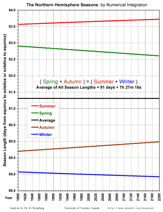 | A numerical integration of the lengths of the seasons within two centuries of the present era (1800 to 2200 AD), plotted at yearly intervals without any averaging. The small wiggles in the plotted lines are not graphic artifacts, but are variations of several minutes from year-to-year caused mainly by gravitational interactions with Moon and to a lesser but non-negligible extent Venus and Jupiter. At year 2007 AD, Spring = about 92+3/4 days and getting shorter, Summer = about 93+2/3 days and getting longer, Autumn = about 89+5/6 days and getting longer, Winter = slightly less than 89 days and getting shorter, with an average season length in this data set of about 91 days 7h 27m 15s. The significance of the changing season lengths will become obvious in chart #2, next below. The Northern Hemisphere dominates global weather patterns because it contains most of the land area. With its Summer being the longest season and getting longer, while Winter is the shortest season and getting shorter, for the next several millennia there will be an unavoidable cumulative trend toward global warming that will be further amplified by contributions due to greenhouse gases, deforestation, desertification, and heat production by human activities. | |
| 1. | 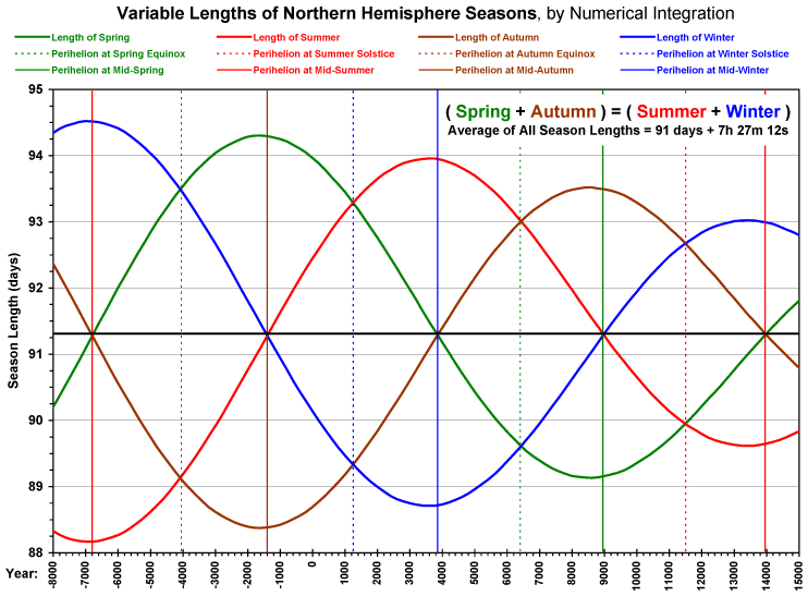 | A numerical integration from 8000 BC to 15000 AD, showing the relationship between slightly more than one perihelion cycle and each of the equinoxes, solstices and seasons. Points are plotted at 200-year intervals, without any averaging, connected with straight line segments. Refer to the description above of the effect of the perihelion cycle on season lengths. In the present era perihelion is about a month ahead of mid-Winter, which it will reach around year 3850, so the length of Winter is approaching an extreme minimum and the length of Summer is approaching an extreme maximum, with correspondingly milder than usual temperatures during both seasons (for the northern hemisphere). The length of Spring will continue its past 2000 year steady decline for about another 4000 years until perihelion approaches the Spring equinox, after which the Vernal Equinoctial Year length will get shorter. Study this chart carefully, in comparison with the description above of the effect of the perihelion cycle on season lengths, otherwise the longer-term charts below won't make much sense! | |
| 2. | 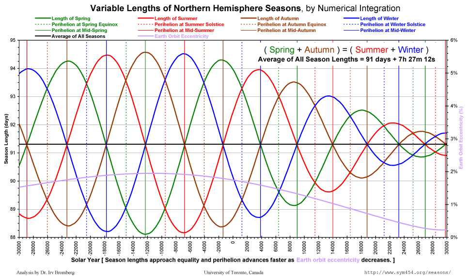 | A numerical integration from 30000 BC to 30000 AD, showing the relationship between the perihelion cycle and each of the equinoxes, solstices and seasons. Points are plotted at 200-year intervals, without any averaging, connected with straight line segments. Refer to the description above of the effect of the perihelion cycle on season lengths. In this longer-range view, spanning nearly 3 perihelion cycles, the relationship between Earth orbital eccentricity (lavender curve, secondary y-axis) and the variations of season lengths is evident. | |
| 3. | 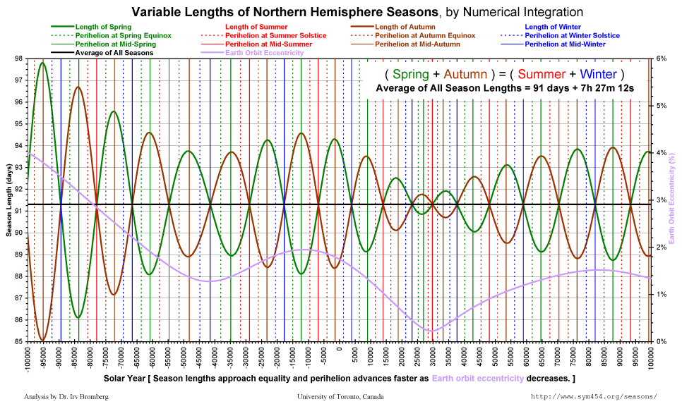 | A numerical integration from 100000 BC to 100000 AD of the lengths of Spring and Autumn, which are only equal when perihelion is at mid-Winter. They are, however, complementary in that their lengths always add up to one-half of the solar year (within a few minutes), so that as one gets shorter the other gets longer by the same amount. Points are plotted at 200-year intervals, without any averaging, connected with straight line segments. Refer to the description above of the effect of the perihelion cycle on season lengths. Here we can easily see that the length of the full perihelion cycle, indicated by the intervals between the color-coded vertical gridlines, varies with the mean Earth orbital eccentricity. Perihelion advances at a faster rate as the orbital eccentricity decreases. | |
| 4. | 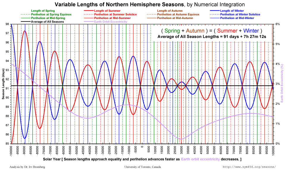 | A numerical integration from 100000 BC to 100000 AD of the lengths of Summer and Winter, which are only equal when perihelion is at mid-Autumn. They are, however, complementary in that their lengths always add up to one-half of the solar year (within a few minutes), so that as one gets shorter the other gets longer by the same amount. Points are plotted at 200-year intervals, without any averaging, connected with straight line segments. Refer to the description above of the effect of the perihelion cycle on season lengths. | |
| 5. | 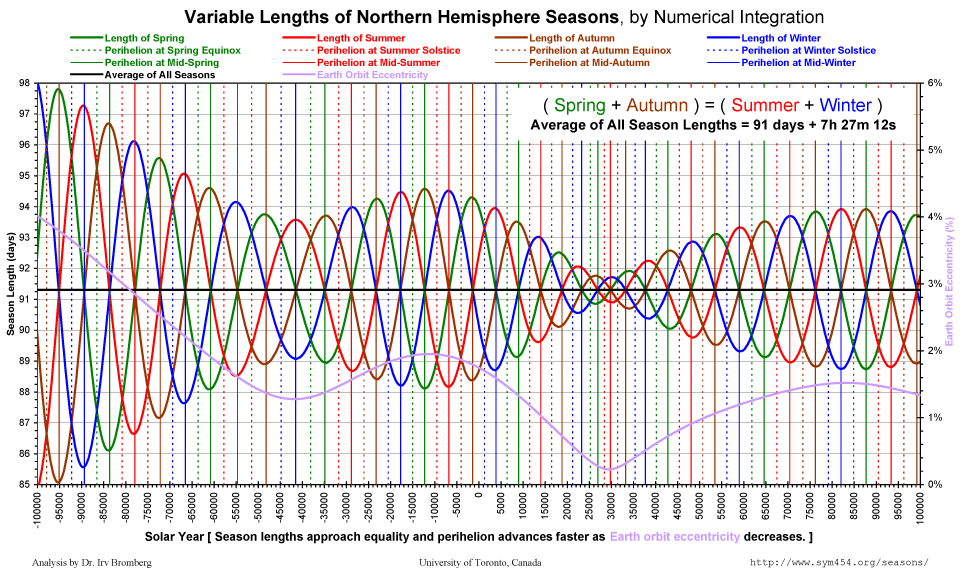 | A numerical integration from 100000 BC to 100000 AD putting all four seasons together, showing season lengths varying from less than 88 days to almost 95 days. Season length variation extremes will be even greater during intervals of higher mean Earth orbital eccentricity, which occur periodically, peaking approximately every 100,000 years. The minimal variation interval near the year 50,000 corresponds to an era when Earth's orbit will be nearly circular. Points are plotted at 200-year intervals, without any averaging, connected with straight line segments. Refer to the description above of the effect of the perihelion cycle on season lengths. Note that when Spring and Autumn are equal at the median, Winter and Summer are at their respective minimum and maximum extremes, but when Winter and Summer are equal at the median, Spring and Autumn are at their respective minimum and maximum extremes, as per chart #2 above. |
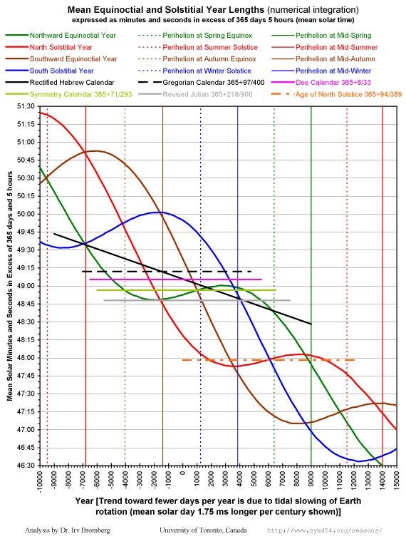
Graphical Analyses of Length of the Solar Year
What is happening to the mean equinoctial and solstitial year lengths as the lengths of the seasons change?
The dominant overall trend is towards fewer days per year (in terms of mean solar days), caused by tidal slowing of Earth's rotation. In terms of the fixed time units of International Atomic Time, however, the average time that Earth takes to orbit Sun is almost constant (see chart #9, below). As the Earth rotation rate slows the mean solar day gets longer (here a steady rate of +1.75 milliseconds per century is assumed), therefore fewer calendar days fit into that constant orbital year length.
Around the time when aphelion reaches an equinox or solstice, its progressively shortening equinoctial or solstitial year length reverses its trend and may enter an era of relative stability lasting up to ten millennia, until around the time that perihelion reaches that equinox or solstice. During such a period of stability, simple fixed arithmetic leap cycle calendars can maintain good alignment with that equinox or solstice.
Over long spans of tens of millennia, however, there are relatively few eras when suitably stable mean solar time equinoctial or solstitial year lengths were or will be available to use with simple arithmetic calendars having fixed leap cycles.
| # | PNG Image | Description and Comments | |
|---|---|---|---|
| 6. | Year Lengths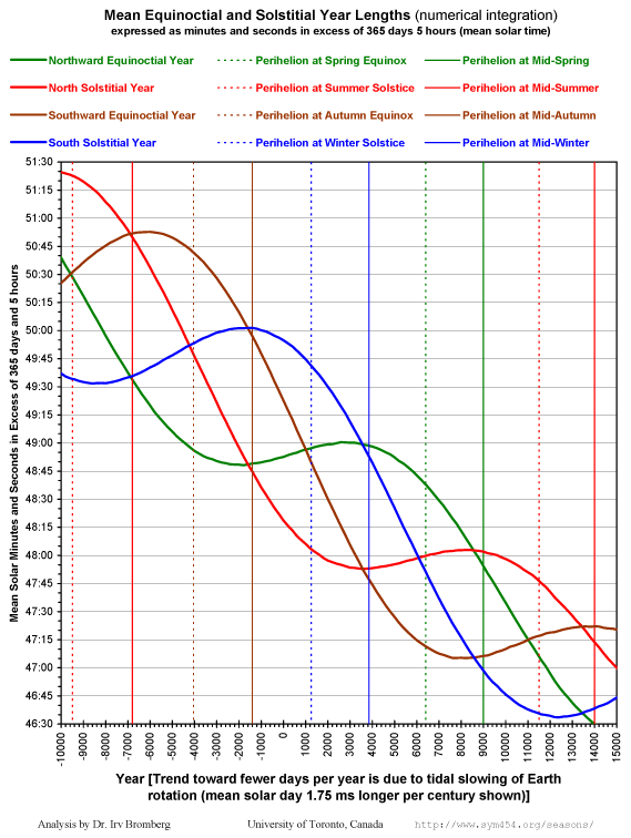 With Calendars Landscape Layout, With Calendars |

Climate, Weather and Aboriginal Culture - Indigenous Seasonal Descriptions
Australia’s climate is diverse. Monsoon tropics, desert, savanna, alpine and temperate regions can all be found in various locations. The sheer diversity of ecological zones negates the concept of a rigid European seasonal calendar for the entire continent. The Aboriginal people of Australia inhabited distinct regions that were usually concordant with geographical and ecological regions. An intimate knowledge of the environment was paramount for survival and the resulting meteorological view of the Aboriginal people is one of great diversity, where the nomenclature of the seasons is often dependant on localised events or resources.
The ability to link events in the natural world to a cycle that permitted the prediction of seasonal events was a key factor in their success. These natural barometers were not uniform across the land but instead used the reaction of plants and animals to gauge what was happening in the environment.
The presences of march flies, for example, was an indication to the Gadgerong people that crocodile eggs could be found, to look for native honey, and it was approaching the late dry season.
As a result of all this, seasonal cycles as described by the various Aboriginal peoples differ substantially according to location.
This produces a far more intricate and subtle overview of Australia’s climate than the 4-season European climate description of Summer, Autumn, Winter and Spring, applied as it is across most areas of the continent.
Table 1 shows a comparison of various Aboriginal seasons from around Australia with the European calendar.
| Aboriginal Seasons | |||||
| Month | European Season | Minang SW WA Temperate | Arrernte Central Australia Desert | Gadgerong NW NT Monsoon Tropics | Tasmania NE TAS Cool Temperate |
|---|---|---|---|---|---|
| December | Summer | Beruc | Uterne | Bandenyirrin (cont) | Wegtellanyta |
| January | Mayurr | ||||
| February | Meertilluc | ||||
| March | Autumn | ||||
| April | Pourner | Alhwerrrpeurle | Nguag/Gagulong | ||
| May | Tunna | ||||
| June | Winter | Mawkur | Alhwerrpa | ||
| July | |||||
| August | Meerningal | ||||
| September | Spring | Ulpulpe | Pawenya peena | ||
| October | Uterne urle | Bandenyirrin | |||
| November | |||||